North Thames River Canoe Route: St. Marys to Delaware
The paddling route from St. Marys to Delaware is scenic, passing through farm fields, forests, urban neighbourhoods, and parkland. It is suitable for the novice to intermediate paddler as there are no difficult rapids, but there are boulders to avoid in low water conditions.
This 71 km route (elevation drop of 94 m) can be paddled as a series of day trips or as a two-day trip.
The maps below show the route, major roads, parks, and obstacles. The river can be accessed from most bridge crossings but there is no infrastructure or maintenance for this purpose. The most popular access points are shown on the maps. These maps, combined with road maps and Google Maps, should provide enough detail for paddling the route.
Download the brochure with maps (printable on 8.5″ x 14″ paper).
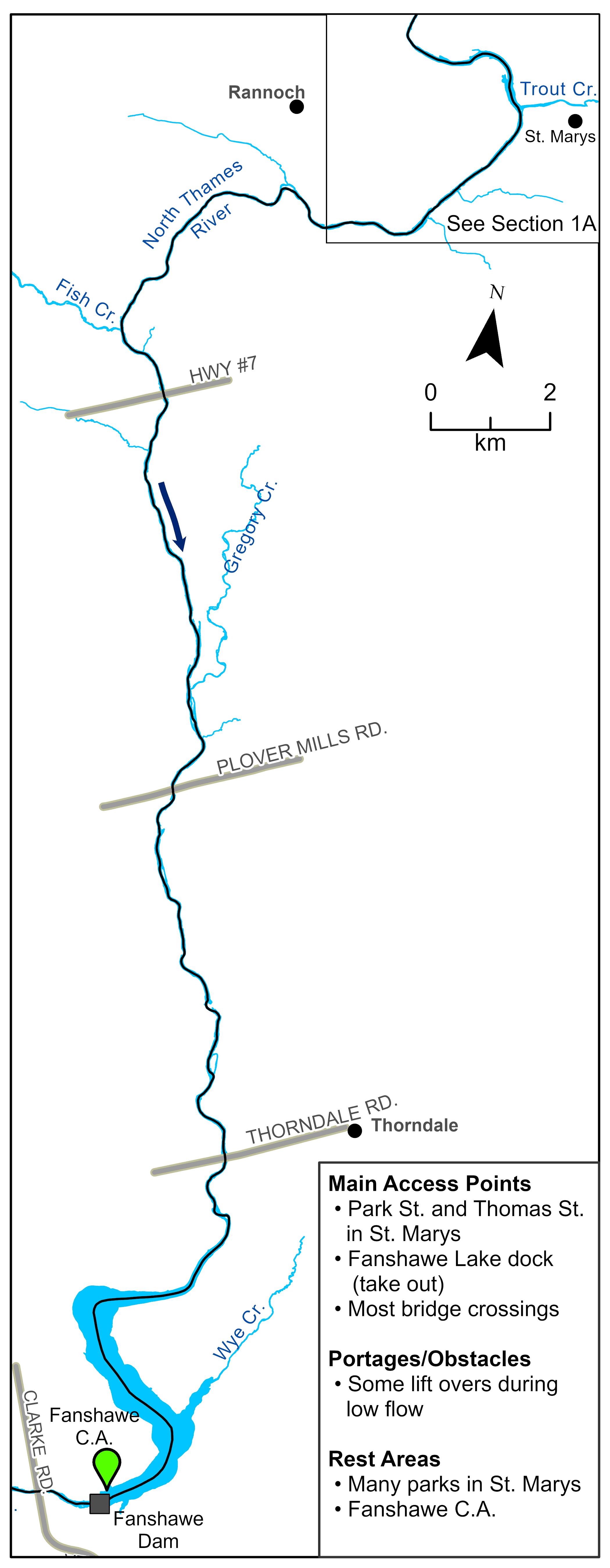
Section 1: St. Marys to Fanshawe Dam
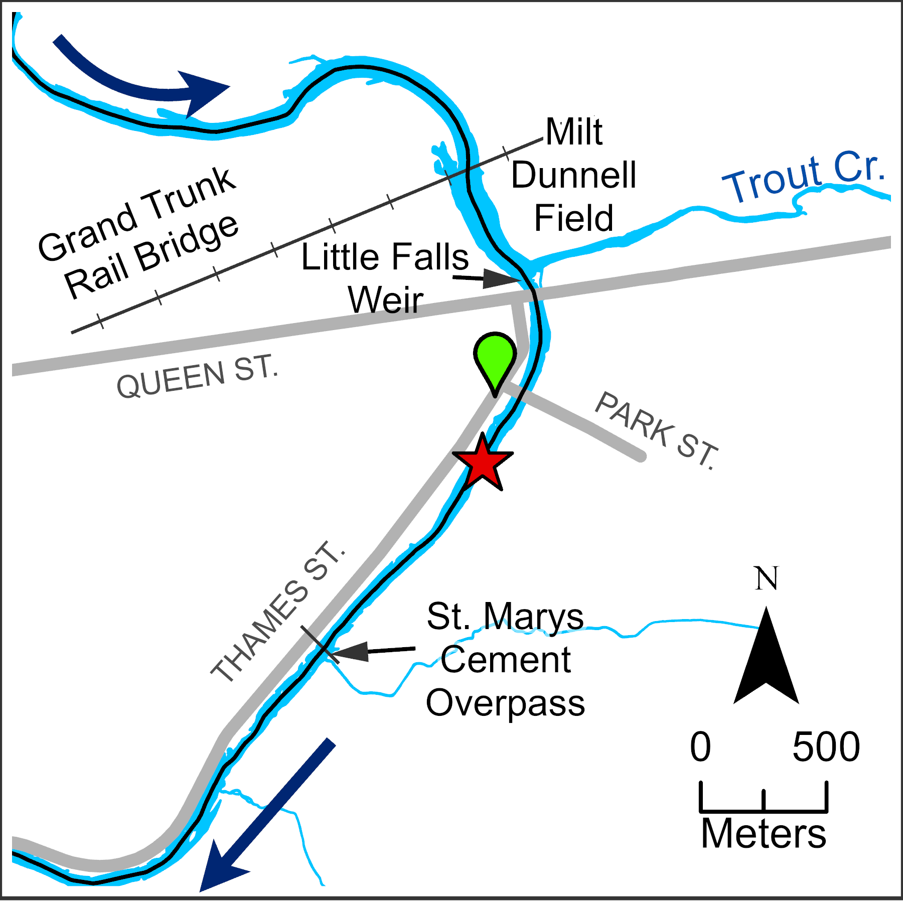
Canoe access is best from the west side of the North Thames River in St. Marys, below Queen St. (e.g., Park Street Bridge near Thomas St.).
As you leave the town and paddle down the North Thames, the river meanders through rolling farm fields and riverside forests.
The river slows and widens as it enters Fanshawe Reservoir. The reservoir is about six km long and used by other boaters, so be aware. Fanshawe Conservation Area (CA) has many attractions including seasonal and overnight camping (519-951-6181, www.fanshaweconservationarea.ca).
Take out your canoe at the docks on the north side of the reservoir just before the dam.
Follow the gravel roads to access the river below the dam. A parking lot and a portable toilet are provided in season. Note: There is no vehicle access into the park past the dam on weekends or evenings in the off-season (December 1 to March 31).
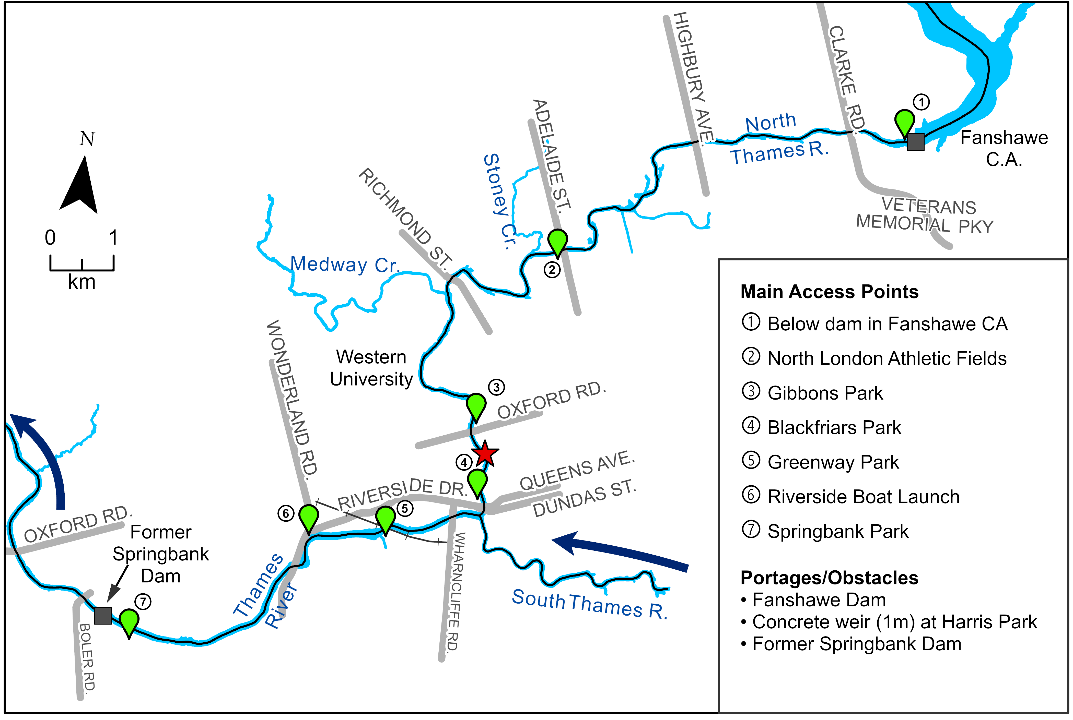
Section 2: Fanshawe Dam to Springbank Park
There are several small rapids as you enter London. You can stretch your legs at any of the riverside public parks (Harris, Gibbons, and Springbank). Most have washrooms or toilets open in the summer.
At the Forks of the Thames in downtown London, paddle around the Walter J. Blackburn Memorial Fountain. The river widens as you enter the main channel of the Thames. Downstream of the railroad bridge, paddlers can take out at the Riverside boat launch access on the right (north) side.
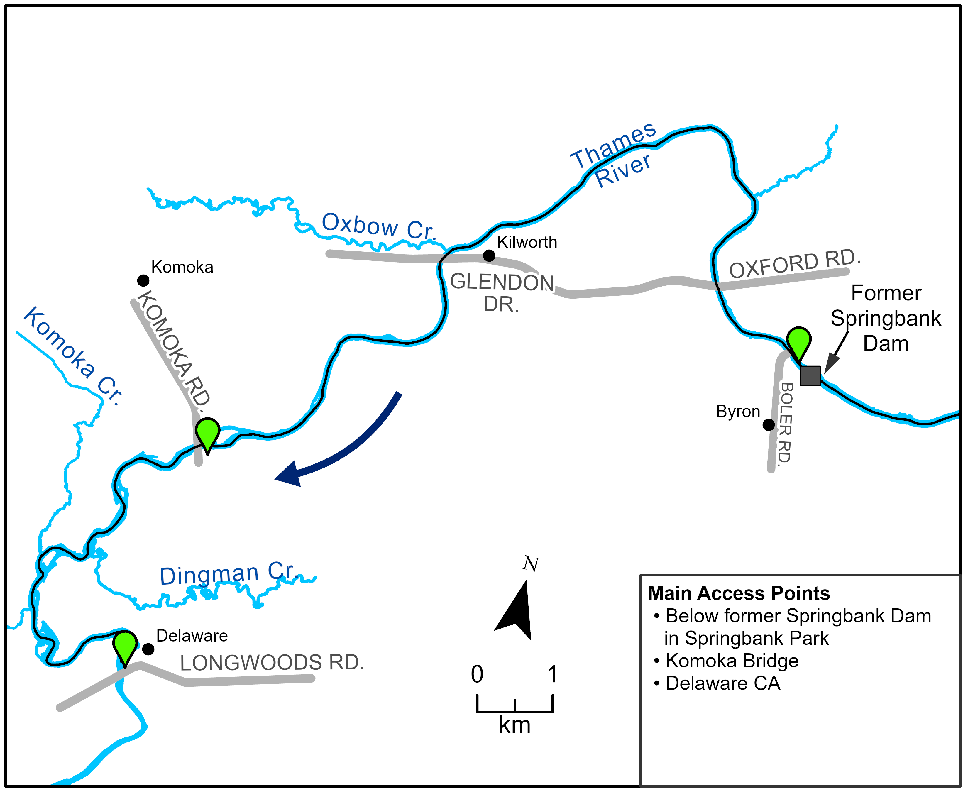
Section 3: Springbank Park to Delaware
About three km downstream of the boat launch is the former Springbank Dam. Part of the dam remains and, in very low water, dam infrastructure on the river bottom may be exposed. Portage around the structure via the left (south) bank. There is a parking lot and washroom nearby in Springbank Park.
Downstream of Springbank Park, the river meanders through larger forests and past steep bluffs. There are several small islands to paddle around.
The landscape flattens near Delaware. Just before the Longwoods Road Bridge, look for a narrow foot trail on the left bank that leads to the parking lot at Delaware CA (Tiffany Park), at Wellington St. and Gideon Dr.
Flow Variability
Flows in the North Thames and Thames River vary significantly throughout the year, ranging from two cubic metres per second (cms) in a dry August to more than 700 cms during flood conditions.
Flows downstream of the Forks are generally more reliable for canoeing, while Section 1 may only be canoeable in early spring. Never paddle during a flood event or when boating bans are in effect. Check real time Thames River flows at www.thamesriver.on.ca. Upstream of the Forks, flows of at least six to 20 cms are generally suitable for paddling.
Canoe Safety
Wear a life jacket, canoe in groups, be alert, and use your judgement. If you are in doubt of a rapid or encounter an obstacle, portage around it. Users are solely responsible for any risks encountered in their use of the river.
Drinking Water
Thames River water is not suitable for drinking. Carry drinking water with you.
Private Lands
Respect the rights of private landowners along the river. Take nothing but pictures.
Plants and Animals
Riverside trees include Manitoba Maple, Basswood, willows, Sycamore, and Black Walnut. Some wildlife you may encounter includes deer, raccoons, turtles, Canada geese, mallards, and great blue herons.
Conservation Area Paddling
Fanshawe, Pittock, and Wildwood CAs rent canoes, kayaks, and/or stand-up paddle boards for use in the reservoirs (visit www.thamesriver.on.ca for more information).
Helpful Links
- facebook.com/ThamesRiverPaddlingRoutes
- facebook.com/LondonCanoeClubON
- londonspaddleshop.com
- orcka.ca
- Thames River from Delaware to Lake St. Clair: lowerthames-conservation.on.ca/about-us/ fees-publications-/canoe-the-thames-maps-and- information
- City of London Fish and Paddle Guide: london.ca/sites/default/files/2020-10/ Fish%20and%20Paddle%20Guide.pdf
- discoverstmarys.ca/en/see-and-do/the-yak-shack.aspx

Section 1: St. Marys to Fanshawe Dam
Section 1A: St. Marys
Section 2: Fanshawe Dam to Springbank Park
Section 3: Springbank Park to Delaware