Surveyors Hit the Ground Running
Kenny Tomljenovic, July 2023
Flood modelling begins with the essential job of watercourse surveying.
Each year, a team of Field Survey Assistants joins the Upper Thames River Conservation Authority (UTRCA) from June to November to collect information about the shape of watercourses all over the Upper Thames River watershed. While waterbodies look flat from above, the ground beneath can be far from it.
“It’s hard to tell where the ground is,” said Collin Branton, GIS Specialist – Water Resources. “So, the Surveyors use GPS equipment to measure the elevation of the ground under the water.”
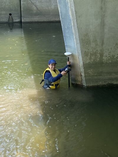
With their chest waders pulled high, the surveyors trek along watercourses, stopping every 50-100 meters to collect GPS data. “They do a lot of bush whacking in all conditions. From farm fields to dense forests, they deal with all kinds of vegetation, bugs, and weather conditions,” said Collin.
At each stop, the surveyors use high accuracy GPS units connected to a satellite receiver that is mounted on top of a two-meter pole. The receiver collects elevation data from satellites, and then transmits that data to a smart phone app via Bluetooth.
The survey team also measures the elevation of any bridges or culverts they come across to determine the size of the bridge opening. This way, Water Information Management staff can develop an understanding of how much water can flow below the bridge or culvert before it floods above it.
This year, we are happy to have Bailey Arnold back in the survey team, and to welcome Kenny Tomljenovic, Michelle Dyment, and Nandini Patel for their first season.
Together, they have surveyed watercourses in three UTRCA subwatersheds, collecting about 4,500 GPS points so far this year.
“This GPS information is the basis for our flood models,” explained Collin. “High quality survey data can help lead to high quality models. So, it’s important to have accurate data.”
During the flood modelling process, the GPS data is combined with elevation data, modelled water flows, and other relevant data to generate flood information.
“Working as a surveyor is a great opportunity to develop new skills and learn your way around the watershed,” said Bailey. “Working outside is a big bonus, plus the data collected makes it possible for flood mapping to be made and potential damage to be avoided!”
We are looking forward to a productive surveying season with an enthusiastic, hard-working team.
Contact: Collin Branton, GIS Specialist, Water Resources