Handheld Unit Flow Readings
Field staff at the Upper Thames River Conservation Authority (UTRCA) regularly take streamflow readings at a number of sites in streams, creeks, and drains across the watershed. Streamflow refers to the volume of water that moves over a designated point over a fixed period of time.
This data is used to indicate hydrologic conditions, as well as the discharge amounts of a watershed. This helps staff understand how high and low water impacts the watershed. This information helps determine ideal water level conditions to promote healthy habitats and improve overall watershed health.
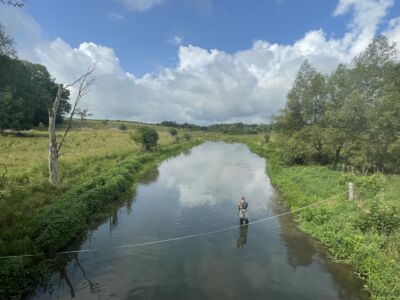
To measure streamflow, staff utilize the SONTEK Flow Tracker 2, a handheld Acoustic Doppler Velocimeter (ADV). First, they set up a tag line (see photo below) with minimal boulders or objects that would displace the water flow, such as islands or large fallen trees. Moving along the tag line, staff use the Flow Tracker 2 to take samples in intervals, capturing an accurate representation of the flow throughout the channel. Once staff have this flow data, it can be used to create rating curves which help with flood modeling, water predictions, and dam operations.
What’s more, the discharge amounts calculated from these measurements, combined with our hydrologic models, enable staff to predict water level and flow amounts for flood bulletins as well as low water alerts.
Contact: Jessica Penz, Water Resources Technician