Recommended Flows for Paddling on the Upper Thames River
The following information is provided to help you make decisions about canoeing and kayaking on the Thames River. We welcome your comments about the flow data and your canoeing experience!
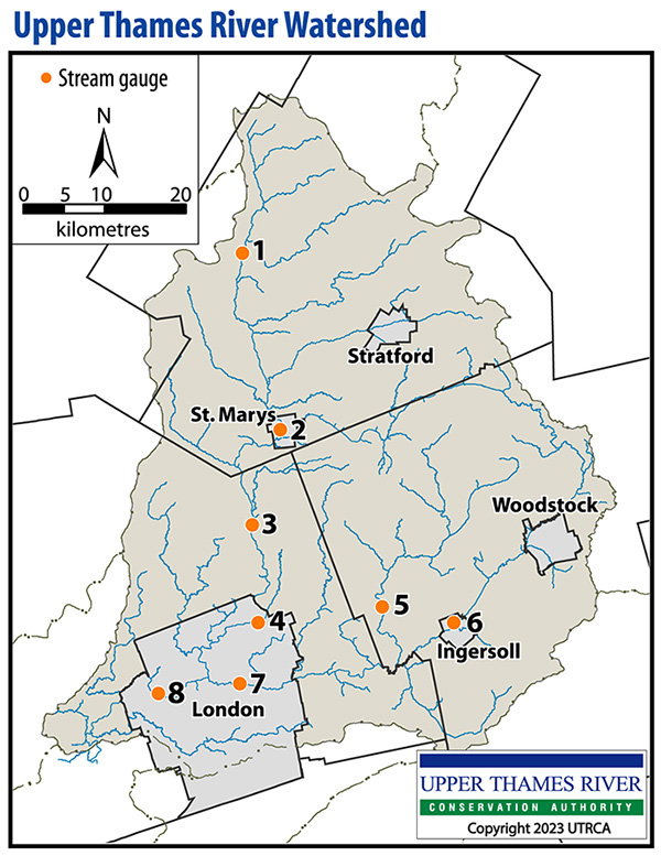
Below are flows we recommend for paddling in different sections of the upper Thames watershed, measured in cubic metres/second (cms or cu.m/sec). To see the real time flows along a particular stretch of the river, click on the stream gauge number and location below or in the navigation menu.

North Thames River
- From Mitchell to St. Marys
- Recommended flow: 5 cms
- Check stream gauge #1 near Mitchell
- From St. Marys to Fanshawe Lake
- Recommended flow: 15 cms
- Check stream gauge #2 at St. Marys
- Check stream gauge #3 near Thorndale
- From Fanshawe Lake to Forks of the Thames in London
- Recommended flow: 15 cms
- Check stream gauge #4 below Fanshawe Dam
Middle Thames River
- From 27th Line of Zorra to Thamesford
- Recommended flow: 3 cms
- Check stream gauge #5 at Thamesford
- From Thamesford to Putnam
- Recommended flow: 3 cms
- Check stream gauge #5 at Thamesford
South Thames River
- From Beachville to Putnam
- Recommended flow: 6 cms
- Check stream gauge #6 near Ingersoll
- From Putnam to Forks of the Thames in London
- Recommended flow: 15 cms
- Check stream gauge #7 near Ealing in London
- Note: Hunt Dam hazard
Note: The South Thames from Woodstock to Beachville is not recommended for paddling, due to the presence of many hazards (e.g., debris, trees across river, etc.).
Thames River (Forks to Delaware)
- From Forks of the Thames in London to Delaware
- Recommended flow: 20 cms
- Check stream gauge #8 at Byron in London
Other Websites
Here are links to other websites with helpful information:
- Thames River Paddling Routes (Thames River Paddling Routes Project – FaceBook page)
- Paddling Routes (Southwest Ontario Tourism Corporation)
- Paddling Plan (City of London)
- Fish and Paddle Guide (City of London)
- Canoe the Thames Maps and Information (Thames River from Delaware downstream)(Lower Thames Valley Conservation Authority)
- Paddling the Thames (Carolinian Canada)

