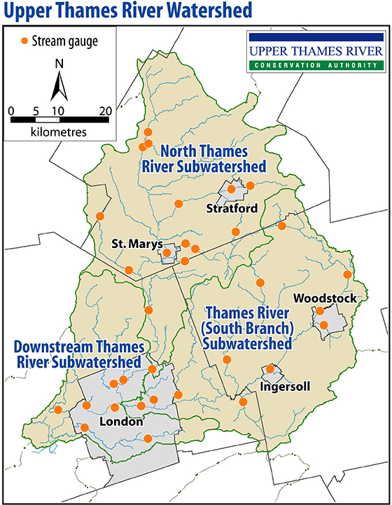
Thames River Flows and Other Information
The Upper Thames River Conservation Authority monitors stream flow and meteorological stations throughout the watershed as part of its flood control program.
- North Thames River stream gauges
- South Thames River stream gauges
- Downstream Thames River stream gauges
The Lower Thames Valley Conservation Authority also has links to the stream gauge network within its watershed.
Access Real-Time Environmental Data
View, graph, and download environmental monitoring data using the Collaborative Water Data Viewer interactive open data portal.
These stations measure parameters such as water level, rainfall and air temperature in real-time, recording values on at least an hourly basis. This information is collected from remote sites via telephone modem on a daily basis during low flow periods and more frequently during floods, and then stored.
Water levels are converted to flows, which are measured in cubic metres/second (CMS).
- 1 cubic metre (1,000 litres) = 2 bathtubs
- 100 cubic metres = an in-ground swimming pool

The UTRCA measures stream flow at 23 locations, rainfall at 16 locations, and reservoir levels at four locations. Other meteorological parameters, such as air temperature, wind speed and direction, and solar radiation, are also measured at some locations. During the winter months, UTRCA staff conduct manual snow surveys on a bi-weekly schedule to provide information on the snow pack.
The information provided by the monitoring system supports the UTRCA’s flood management and low flow response activities, as well as day to day operations of the water control structures such as Fanshawe, Pittock and Wildwood Dams. In recent years, recreational users of the river have also been interested in this information.
As flood control is a provincial responsibility, delegated to Conservation Authorities where they exist, much of the funding for this system comes from the Ontario Ministry of Natural Resources and Forestry. Many of the stream flow stations are operated by the Water Survey of Canada. Stream gauge stations are cooperatively managed through a cost-share agreement between the Province of Ontario and the Federal Government, in partnership with the Conservation Authority.

