London Dyke Inspection (2004)
In 2004, the UTRCA undertook a condition assessment of the Thames River dykes within the City, including the West London Dyke. Approximately 350 m of the West London dyke north from the Queens Avenue Bridge were identified as being the highest priority for repair. This portion was originally built in the 19th century in order to minimize flooding in the West London area. The concrete revetment in place in 2004 (pictured below) dated to the 1930s.
- 2004 Inspection of Flood Control Structures in the City of London (main report)
- Appendix 2 – Stantec memo summarizing findings
- Appendix 3 – Site Map
- Appendix 3 – Inspection Sheets & Maps – Ada – Jacqueline
- Appendix 3 – Inspection Sheets & Maps – Broughdale
- Appendix 3 – Inspection Sheets & Maps – Byron
- Appendix 3 – Inspection Sheets & Maps – Clarence – Nelson
- Appendix 3 – Inspection Sheets & Maps – Coves
- Appendix 3 – Inspection Sheets & Maps – Riverview – Evergreen
- Appendix 3 – Inspection Sheets & Maps – West London
- Appendix 4 – Site Photos – Ada – Jacqueline
- Appendix 4 – Site Photos – Broughdale
- Appendix 4 – Site Photos – Byron
- Appendix 4 – Site Photos – Clarence – Nelson
- Appendix 4 – Site Photos – Coves
- Appendix 4 – Site Photos – Riverview – Evergreen
- Appendix 4 – Site Photos – West London
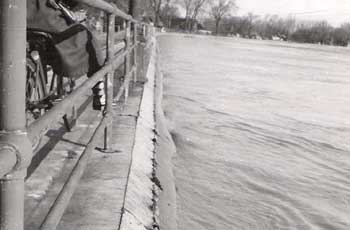
West London Dyke, April 1947 Flood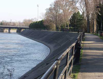
West London Dyke before the replacement project, looking south towards the Queens Street bridge