West London Dyke Master Repair Plan
The West London Dyke is approximately 2,300 m long and runs along the west bank of the north branch of the Thames River extending north of Oxford Street to the Forks of the Thames River and then along the north bank of the main branch to the west of the Wharncliffe Road Bridge and terminating in Cavendish Park. The West London Dyke is primarily an engineered structure which protects life and property during periods of extreme river flows. The City of London owns the dyke and through an agreement, the Upper Thames River Conservation Authority (UTRCA) undertakes major maintenance activities.
The UTRCA retained Stantec Consulting Ltd. in 2009 to complete a Master Repair Plan covering the next 20-year period to address aging infrastructure, flood protection, public use, and integration of other City initiatives. The study was placed on hold in early 2013 pending updates to flood elevation information. Having incorporated the updated flood elevations, the Master Repair Plan has now been completed.
This study was conducted as a Master Plan (Phases 1 and 2) under the Municipal Class Environmental Assessment process (Municipal Engineer’s Association, as amended in June 2007 and 2011). Under this process, First Nations, agency and public input was invited through three public information centres for incorporation into the planning and design for this study. This Notice hereby serves as the Notice of Completion for the Schedule B projects identified within the Master Repair Plan. Potential Schedule C projects identified within the Master Repair Plan will be subject to further evaluation and consultation.
- Notice of Completion
- Executive Summary
- Main Report (including table of contents)
- Appendix 1.1: 2007 Amenity Master Plan
- Appendix 2.1: Contact List
- Appendix 2.2: Agency and Stakeholder Responses
- Appendix 2.3: Aboriginal Consultation Log
- Appendix 2.4: Aboriginal Consultation Responses
- Appendix 2.5: Public Information Centre 1
- Appendix 2.6: Public Information Centre 2
- Appendix 2.7: Public Information Centre 3
- Appendix 2.8: Notices
- Appendix 4.1: West London Dyke Plan and Profile Drawings
- Appendix 6.1: Cultural Heritage Evaluation Report
- Appendix 6.2: Stage 1 Archaeological Assessment Report
Public Information Centres during the Project
Two Public Information Centres (PIC) were held prior to 2013 to solicit public input (see the poster boards for PIC 1 and PIC 2). The study was placed on hold in early 2013 pending updates to flood elevation information. The third and final Public Information Centre was held on September 10, 2015 (see the notice, poster boards and comment form for PIC 3).
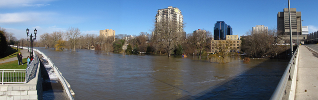
West London Dyke (at left) from the Queens Street bridge, December 2008 (photo: Dave Colvin)
See Other West London Dyke Projects
For more information, please contact:
Huda Ghadhaban, P.Eng., Engineering Coordinator, Water and Erosion Control Structures, Upper Thames River Conservation Authority, or Monica McVicar, P. Eng., Environmental Services Engineer, Stormwater Engineering Unit, City of London